

Recording and mapping
Recording and mapping of mining facilities
Calculation of stocks
Calculation of stocks and piles and extracted minerals
GIS capabilities
Full utilization of GIS capabilities
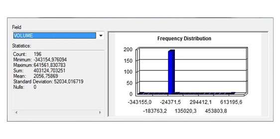
Volume measurements
Volume measurements
Design & monitoring of blasting
Design & monitoring of blasting in mines
Hydrological measurements
Hydrological measurements
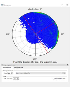
Geological applications
Geological applications
Ασφάλεια
Ασφάλεια κατά τη διαδικασία καταγραφής δεδομένων
Χαμηλή επικινδυνότητα
Χαμηλή επικινδυνότητα για ανθρώπινο δυναμικό
Μικρότερο κόστος
Μικρότερο κόστος
Λιγότερος χρόνος
Λιγότερος χρόνος για την επιθεώρηση
Aνάλυση & ακρίβεια
Υψηλή ανάλυση και ακρίβεια καταγραφής
Real time επιθεώρηση
Real time επιθεώρηση στο έδαφος από πολλούς τεχνικούς ταυτόχρονα
Post inspection
Post inspection αφού όλα τα δεδομένα καταγράφονται
Διατήρηση αρχείου
Δυνατότητα διατήρησης αρχείου με όλες τις επιθεωρήσεις σε βάση δεδομένων
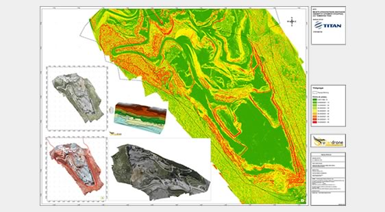
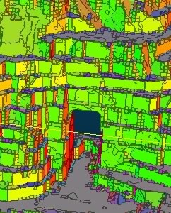
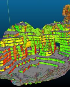
Recording and mapping of mining facilities
High resolution and accurate mapping in order to produce three-dimensional models of the mine and the processing infrastructure.
Creation of topographic diagrams, maps and other deliverable products that contribute to the systematic and efficient supervision of the production process.
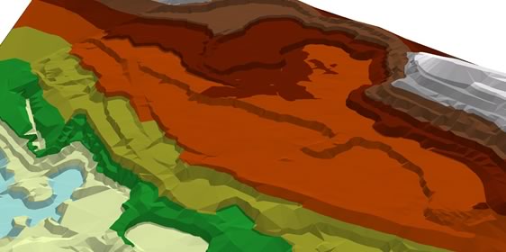

Calculation of total stocks and piles and extractedminerals
The correct determination of the extracted rock volume as well as the corresponding reserve, are crucial factors for the efficient operation of a mine.
The aerial mapping method offers a high-resolution 3D model of the mine in a very short time and cost, which makes it unbeatable compared to conventional methods.
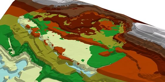
Application of GIS capabilities
Data Analysis of mining procedures
By combining Geographic Information Systems with remote sensing data from unmanned systems, we are able to integrate, process, analyze and visualize all the useful data of a mining / quarrying process, which we can be saved at geo-database, greatly facilitating and optimizing the entire production process.
Application of GIS capabilities with a single measurement for:
Topographic recording and mapping
Volume measurements
Rock integrity analysis
Slopes analyzing
Hydrological measurements
Geological applications
chat